James Balog: Time-lapse proof of extreme ice loss
סרטים של קרחונים יבשתיים בקו שבו הם נשברים ומתפזרים כהרי קרח בים. שצולמו ע"י מצלמות שצילמו תמונה כל 15-60 דקות ודחסו לפעמים שנים לדקות. כמובן כול קרחון שמגיע לים מתפרק בצד הים והמשקעים בונים אותו ביבשה כך שמתקיים שיווי משיקל דינמי כל עוד התנאים קבועים.החלק המדהים הוא אחרי ההקדמה (פילוסופיה - ציוד...) הסרטים שצולמו ע"י המצלמות בפינה הימנית העליונה יש אפשרות למלא את הצג
הצצה קטנה לחלק מהכוחות שאנחנו מעוררים
עדכון לסרטים מההרצאה וסרטים נוספים באיכות גבוהה כולל מסך מלא וחד
שתי הערות:
1. עובי קרחון קולמבייה נשמע לי קצת מפתיע בכול מיקרה מבט על
2. אילוליסאט Ilulissat ידועה גם בשם הדני שלה יעקובסוואן Jakobshavn
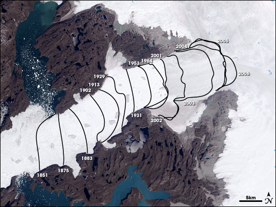
נסיגת חזית השבירה של יענקלה לפי לויני נאסא
The Jakobshavn Glacier in western Greenland drains the central ice sheet, and it is retreating inland faster than any other. This image shows the glacier in 2001. The glacier flows from upper right to lower left. The fjord beyond the glacier terminus is packed with seasonal ice and icebergs. Terminus locations before 2001 were determined by surveys; more recent contours were derived from Landsat data. Without measurements of ice thickness, however, the picture of ice loss is incomplete. (NASA image by Cindy Starr, based on data from Ole Bennike and Anker Weidick (Geological Survey of Denmark and Greenland) and Landsat data.)
by Kendall Haven • design by Robert Simmon • August 28, 2007 - Earth Observatory - NASA

אין תגובות:
הוסף רשומת תגובה